

Variable Rate Irrigation - How Remote Sensing and In-field Info Boosts Efficiencies
Discover how thermal, multispectral, and real-time soil moisture data enable precision irrigation that saves water, cuts costs, and improves fruit uniformity for orchard farming.

Remote sensing and soil probes are quietly changing the way farmers irrigate.
The combination of thermal imagery, multispectral data, and real-time soil moisture readings is enabling something powerful… Variable Rate Irrigation (VRI).
The result? Efficient water use, lower energy costs, and fruit that’s consistently closer to the target peak size for your market.
The Traditional Approach – One Size Fits All
Conventional irrigation systems apply the same amount of water to every part of a block. It’s simple, but it assumes uniformity that rarely exists in real orchards and vineyards.
Soil texture, drainage patterns, root depth, slope, tree health, canopy size, crop load, and localised microclimates (and more!) all influence how much water a plant actually needs.
The outcome? Some trees end up overwatered, others stressed with too little. This leads to inefficiencies and wasted inputs and/or uneven fruit quality.
The New Approach? Data-Driven Precision
Instead of relying on visual checks or fixed irrigation schedules, VRI uses multiple data sources to guide every watering decision. These tools work together to identify stress, measure plant health, and pinpoint exactly where intervention is needed.
VRI changes the game by tailoring water application rates to the unique needs of specific zones. It works by combining…
Thermal imagery: Identifies canopy temperature differences that signal water stress before it’s visible.
Multispectral imagery: Tracks plant health via indices like NDVI and NDRE to pinpoint underperforming zones.
Soil moisture probes: Deliver real-time data on water availability at different depths, showing exactly when (and where) to irrigate.
“You can’t manage what you can’t measure. And with VRI, the measuring is constant and precise.”
From Insight to Action - How VRI Works in Practice
Once the data is in hand, the process shifts from analysis to action.
The power of VRI lies in how seamlessly insights are converted into irrigation decisions, ensuring that adjustments happen at the right place and time.
Here’s the flow (excuse the pun) in high-performing VRI systems:
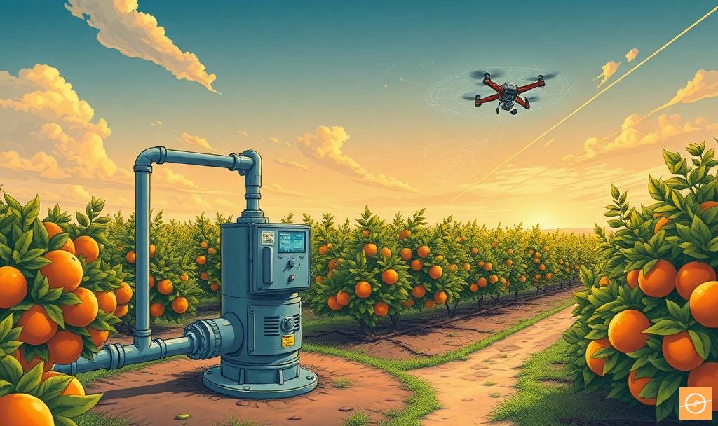
Survey & Mapping: A drone or satellite collects thermal and multispectral imagery, overlaying it with block maps.
Zone Definition: Data is analysed to create irrigation zones based on plant health, soil characteristics, and stress indicators.
Validations: In-field checks and probe readings confirm the findings, ensuring decisions aren’t made on imagery alone.
Prescription Maps: Variable rate maps are uploaded into the irrigation controller or pivot system.
Dynamic Adjustments: Soil probe data or advanced in-field telemetry triggers fine-tuning, ensuring plants get the right amount of water even as weather changes.
How Drone Data Informs VRI
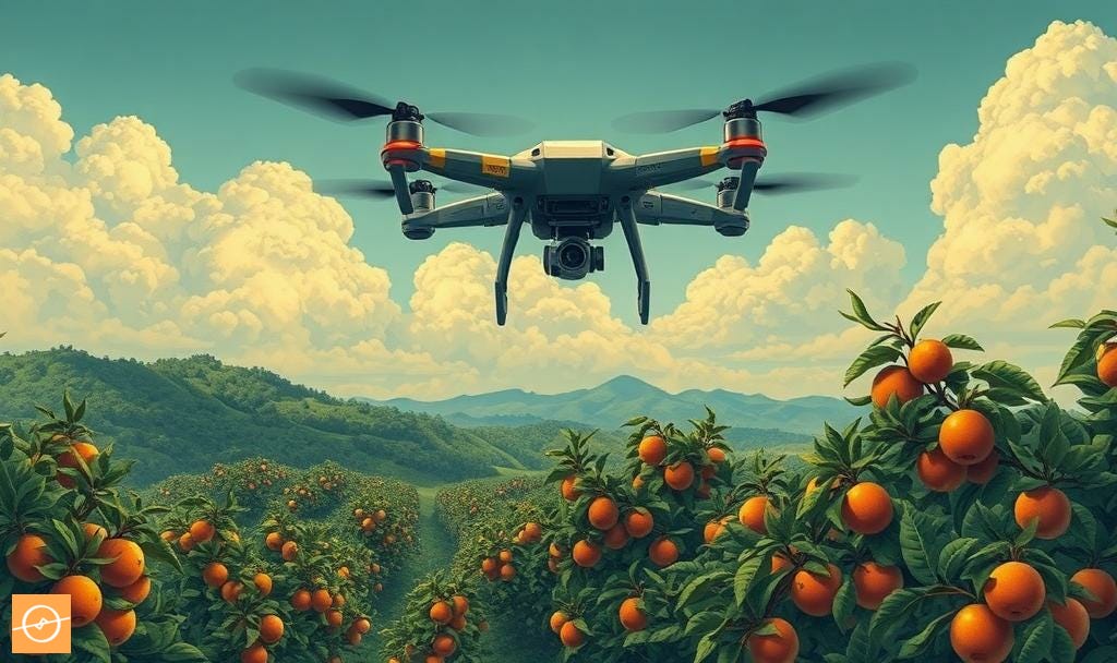
One of the most powerful enablers of VRI is accurate, up-to-date aerial imagery.
Drones equipped with thermal and multispectral sensors can capture orchard or vineyard data at resolutions far higher than satellites or manned aircraft can.
This level of detail means stress patterns, soil variability, and canopy differences can be identified with precision; and acted upon quickly.
The process starts with a scheduled drone flight over the block.
Within hours, processed maps reveal:
Thermal signatures: Canopies running warmer than their neighbours, are often a sign of water stress; or water-logged conditions where moisture uptake has halted in anaerobic conditions.
Vegetation indices: NDVI or NDRE values that show where plant vigour is lower or nutrient uptake is uneven.
Soil patterning: Variations in water retention linked to soil type or compaction, visible when paired with DEMs (digital elevation data).
Canopy metrics: Size, density, and health variations that influence how much water a plant can use effectively.
Once these insights are layered into a GIS or irrigation management platform, they guide zone creation for VRI. Instead of applying the same irrigation recipe across the board, farmers adjust volumes and timing according to the actual conditions captured in the latest scan.
Drone-derived data doesn’t replace on-the-ground measurements.
It amplifies them.
By marrying aerial insights with soil probe readings and AgTech in-field telemetry solutions, production teams can make irrigation decisions that are both highly targeted and responsive to change.
In VRI, that combination is the difference between average and exceptional water management.
Benefits Beyond Water Savings
While reducing water use is a key driver for adopting VRI, the benefits extend deep into day-to-day orchard management.
In many operations, the irrigation system isn’t just delivering water… it’s also the main channel for fertilisers, trace elements, and bio-stimulants.
Precision in water delivery means precision in nutrient delivery. This ensures that inputs reach plants in the right place, at the right time, and in the right amount.
Here are some of the biggest advantages producers are seeing:
Lower pumping costs: Less water moved means less energy spent.
Improved fruit size uniformity: Balanced water distribution reduces small or misshapen fruit.
Better yield quality: Optimal hydration supports sugar development, firmness, and storability.
Reduced disease risk: Avoiding overwatering helps minimise fungal and bacterial outbreaks.
Targeted nutrient delivery: Fertilisers and bio-stimulants applied through irrigation are distributed more evenly, reducing waste and improving uptake.
Yes, VRI requires investment in sensors, mapping, and control systems. But the payback comes quickly (often within a season) through input savings and higher pack-out rates.
A positive spin-off? Some producers report improved market access as they meet sustainability targets tied to water use efficiency. In a world where resources are under pressure, that’s a competitive edge worth having.
VRI isn’t about throwing out your current irrigation system. It’s about upgrading it (and your mindset) to think smarter and act faster.
Pairing remote sensing with soil moisture probes helps us in bridging the gap between data collection and real-time action. Turning precision irrigation from a concept into a daily reality.
By optimising both water and nutrient placement, VRI turns irrigation from a uniform task into a precision management tool.
The gains aren’t just in efficiency; they’re in healthier plants, better fruit, and a more predictable outcome at harvest.
In farming, every drop counts.
AgTech for Citrus at Scale: Emerging Solutions for Global Challenges

The citrus industry is no stranger to volatility. From market cycles and biosecurity threats to extreme weather and rising input costs, global producers have long operated on a knife’s edge. But the current landscape is different. We’re not just contending with cyclical risks – we’re facing structural shifts.
Why Manual Fruit Assessment Falls Short – and What to Use Instead

The Hidden Problem in Orchard Sampling